This website is an archive from 2016
This site was actively maintained from 2006 to 2016. Since then I have kept it online for historical interest, but have made no further updates. Much of the information in these pages is now incorrect or obsolete.

Bay of Kotor
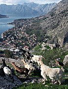
St Ivan's Fortress
Kotor and Surroundings
The Bay of Kotor (Boka Kotorska, also known as the Gulf of Kotor) is one of the most distinctive landscapes anywhere on the Mediterranean. It would be worth visiting just to enjoy the spectacle of the sheer mountains plunging into the Adriatic. Combine this natural drama with mansions, churches, fortifications, and flower gardens and you have one of the most enjoyable destinations in the Balkans.
Kotor
The city of Kotor lies at the innermost point of the bay, just below Mount Lovćen. It's strong identity as a seafaring city seems to persist regardless of varying political affiliations - it has changed rulers fourteen times. It seems to assert the value of urban civilisation in the face of the forbidding landscape that surrounds it, with the help of an imposing set of walls. In these respects it has much in common with Dubrovnik, the larger walled city a short distance to the north. But it is much more than just a poor man's Dubrovnik. Within the walls it has retained a much more mediaeval feel. A map of the old city shows hardly a single right angle; the town consists of a maze of tiny alleys that meet unexpectedly to form "squares" that are anything but square. Overshadowed by both towering cliffs and the high walls of four-storey stone houses, some of these narrow lanes must never see sunshine. One of the great pleasures of Kotor is wandering at random through this little labyrinth.
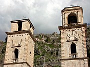
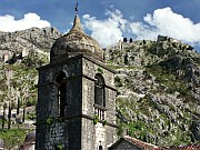
Old Town, Kotor
At some point in your rambles you are bound to find yourself in front of St Tryphon's Cathedral - its two square towers are the city's most identifiable landmarks. It's an essentially Romanesque building, with later additions, and the interior is particularly impressive. You'll come across many other churches in the town, some of them very small indeed. There is a mixture of Catholic and Orthodox churches, built with Venetian and Byzantine influences, illustrating the mixing of faiths that has been a feature of the city's history.
Make sure you allow time to climb the city walls to the Fortress of St Ivan, passing the Chapel of Our Lady of Salvation along the way. The steps begin at the northwest corner of the city (when I was there the entrance was clearly identified by piles of litter). It's a stiff climb so don't set off without something to drink: there are 1350 steps according to the Bradt Guide, 1500 according to Lonely Planet. From the highest point the ground drops away sharply on three sides, with the rooftops of Kotor immediately below. To the north you can see the whole inner part of the bay. Look out for a dome near the shore to the west - it belongs to the implausibly large church in the village of Prčanj. When you have finished admiring the view you can scramble around the crumbling ruins with a freedom rarely found in more litigious countries - the only ones likely to challenge you are the goats.
An interesting alternative approach to the fortress starts outside the city, on the far (northern) side of the moat. It's a slightly untidy semi-industrial area, but you should be able to find a path marked by red and white blazes. The trail leads to grassy terraces and a tiny chapel whose existence you would hardly suspect from down below. From here the trail continues across the cliff and to the fortress. You have to climb in via a window - even this bit has the "official" trail marking. Alternatively you could continue uphill from the chapel via an apparently endless series of switchbacks. I didn't have time to explore, but I suspect this path eventually joins the famous road to Cetinje.
Excursions from Kotor
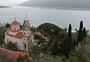
Savina Monastery, Herceg Novi
The Boka Kotorska and the Adriatic Coast
The Bay of Kotor is one of the most dramatic landscapes in the Balkans. It is often described as the Mediterranean's largest fjord. In the strict geological sense it isn't a fjord at all, as it is not the result of glaciation, but the word seems appropriate to convey something of the grandeur of the scenery. The complex topography gives rise to an equally complex climate, with the nearby Orjen mountains ranking among Europe's rainiest places.
Strung out along the shore are settlements such as Prčanj, Dobrota, Perast, and Risan, with stone harbours, Venetian-style villas, churches, and flowers that contrast wonderfully with the towering rock walls. A stroll from Kotor to Dobrota makes a pleasant short excursion from Kotor. Perast is the most interesting of these towns thanks to its especially rich maritime heritage. Out in the bay two churches sit on islands so small that the buildings appear poised to float away on the tide. On the natural island of St George is a monastery sheltered by cypress trees; an artificial island supports the Chapel of Our Lady of the Rocks. This island was built by the locals, although the details of how and when they did this vary wildly depending on who is telling the story. In summer boats ferry tourists to both islands.
Herceg Novi is at the mouth of the Bay, near the Croatian border. It's an important resort and there has been quite a lot of rather unattractive development along its beaches. The steeply sloping old town is much more likeable, and the town's sunny climate is reflected in a profusion of flowers. A few kilometres to the east, the Savina Monastery is beautifully located on a headland. If you have been travelling south down the Adriatic Coast this is probably the first Orthodox monastery you have come across, and it shows an appropriate mixture of Baroque and Byzantine influences. Pop into the main church to admire the iconostasis. You can walk here from Herceg Novi along the seafront, and return via a lovely shaded pathway from the gate of the monastery.
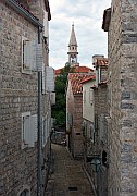
Old Town, Budva
Leaving the Bay of Kotor behind, the seaside resort of Budva is on the open sea a short distance south of Kotor. Budva also has an "old" walled town, but the word "old" could be misleading in this case. An earthquake in 1979 damaged many Adriatic towns, and Budva was hit harder than most. The town you see today is mainly a reconstruction, apparently a very faithful one using the original stones. It lacks the mystique of Kotor but it's a pleasant place nevertheless, at least in the off season when its narrow lanes are quiet. The stone buildings house various fashionable (and sometimes quite expensive) boutiques and bars. From a distance the town looks more authentically old, with the unfortunate exception of an ugly water polo stadium on the waterfront.
There are good beaches along the coast in both directions. Near to the town the beaches are backed by cafes, shops, and stalls that are mostly closed outside of summer. To the south is Sveti Stefan, an old fishing village on an island connected to the mainland by a causeway. The whole island was turned into a hotel complex in the 1960s, and ever since it has apparently been compulsory for travel journalists writing about Montenegro to mention it. Non-guests are charged an entry fee.
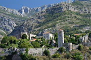
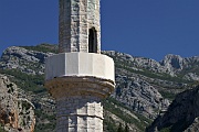
Stari Bar
Further south again is the relatively uninteresting modern port of Bar. The main reason to come here, other than to catch a ferry, is to see the ruined citadel of Stari Bar. The old town has a wonderful location amongst olive groves and cypresses in the coastal hills. Earthquakes and neglect have left their mark on the buildings, but there is still plenty to see within the site, and wandering around its peaceful lanes and staircases is a very pleasant experience. In winter you may find the old town's single gate firmly locked, so try to check with a tourist office before setting out. Behind the citadel some interesting paths and mule tracks lead into the Rumija Mountains. I came across a Muslim cemetery there, in an evocative location overlooking the Adriatic from a great height, but I'm not sure if I could find it again.
Cetinje
Kotor is linked to Cetinje by a road of many hairpin bends that parallels the Ladder of Cattaro, the mule track that linked Cetinje to the outside world until the late nineteenth century - the supply line for essential provisions such as billiard tables. There is an easier and less spectacular (but still scenic) route via Budva - this is the one used by all buses. Whichever you choose, in one sense this is a journey into "the real Montenegro", as the coastal towns were united with the mountainous interior only relatively recently.
Cetinje is the traditional capital of Montenegro, a role it lost to Podgorica in the twentieth century and sadly appears unlikely to recover. It must have been one of Europe's strangest capitals, located as it is on one of the few patches of flat ground in a region of barren mountains. It is now a rather sleepy place and the main attraction is simply strolling its tree-lined streets, savouring the contrast between the wild surroundings and the town's palaces, government buildings, and former foreign consulates. A fading map on the wall of a building in the main square identifies all the places of historic interest. The map has become part of history itself, pointing out the road to Titograd, the former name of Podgorica.
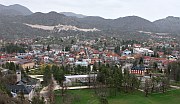
Cetinje (from the Eagle's Crag)
Towards the west of town is the Biljarda Palace, the fairly modest residence of several Princes of Montenegro. It is named after the billiard table that was hauled up the Ladder of Cattaro (I wasn't kidding). Nearby another modest palace now houses the State Museum. Outside a signpost indicates the directions to some museums of almost equal importance in other countries, such as the Louvre and the Hermitage. Don't set your heart on visiting either place, especially in the off season - the opening hours seem to be rather irregular.
Further west again is Cetinje Monastery, rebuilt several times over the centuries and relatively modern in appearance. It is surrounded by an attractive area of parkland, from the southern edge of which a path winds uphill to Orlov Krš, the Eagle's Crag. The crag overlooks the town and is the best place to appreciate the improbability of a capital city in these surroundings. In the other direction you will see either a lot of cloud and mist or the summit of Mount Lovćen, Montenegro's eponymous Black Mountain.
Practicalities
Getting around this part of Montenegro by bus is straightforward. There are at least 20 daily buses linking Herceg Novi, Kotor, Budva, Cetinje, and the capital Podgorica. The trip from Herceg Novi to Kotor takes about an hour, Kotor to Budva half an hour, and Budva to Cetinje 45 minutes. A few buses from Herceg Novi to Budva avoid the town of Kotor and cross the bay by ferry (preko trajekta). Minibuses run between Kotor and Perast, and between Budva and Sveti Stefan.
There are also good bus connections between Budva and Bar. Stari Bar is a 40 minute walk from Bar's bus station, in the opposite direction to the town centre. The walk back from Stari Bar is downhill and easy enough, but in hot weather a taxi is definitely worth considering for the uphill leg.
Budva and Herceg Novi are important seaside resorts. This means that they get crowded in July and August, but it also means that for the rest of the year they have plentiful accommodation in both hotels and private rooms. Kotor is less of a beach resort but also has quite a few places to stay. Cetinje has limited facilities for visitors and is most often visited on a day trip from the coast.
What they said about Kotor and Cetinje ...
The road from Cattaro [Kotor] to Cetinje has been so often written of that it is idle to describe it once again, nor can any words do it justice.
- Edith Durham, 1904
The Gulf of Kotor is one of the most remarkable natural phenomena in Europe, the climax of the whole coast, and the most awe-inspiring entrance to Montenegro. Whether you enter it by sea or by one of the two main land routes the sight of it will last a lifetime.
- J.A. Cuddon, The Companion Guide to Yugoslavia, 1968
I drove up the precipitously corkscrew road that used to be called the Ladder of Cattaro, away from the flowered Adriatic coast to the harsh high plateau of the Lovćen massif - waterless, apparently soil-less, and stubbled only with arid patches of scrub. Crouched in a declivity of this wilderness is Cetinje, which was for a decade or two around the turn of the century the undisputed capital of Ruritania.
- Jan Morris, Fifty Years of Europe, 1997
The Gulf of Kotor, suddenly seen from the top of the Lovćen Pass, is literally heart-stopping. But here, following Edith Durham's sensible example, I rest my pen.
- Dervla Murphy, Through the Embers of Chaos, 2002
More photos of Kotor and Boka Kotorska in my Montenegro Galleries